GPR-SLICE Installer (for network licenses) - 10 June 2025 (v7.3.0.81)
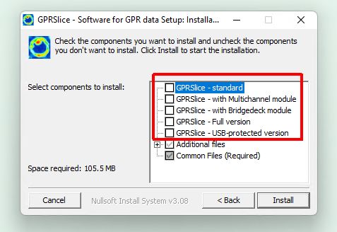
Please remember to select proper version of the product
In silent installer mode, -v switch can be used to select product version (-v standard, -v multichannel, -v road, -v usb)
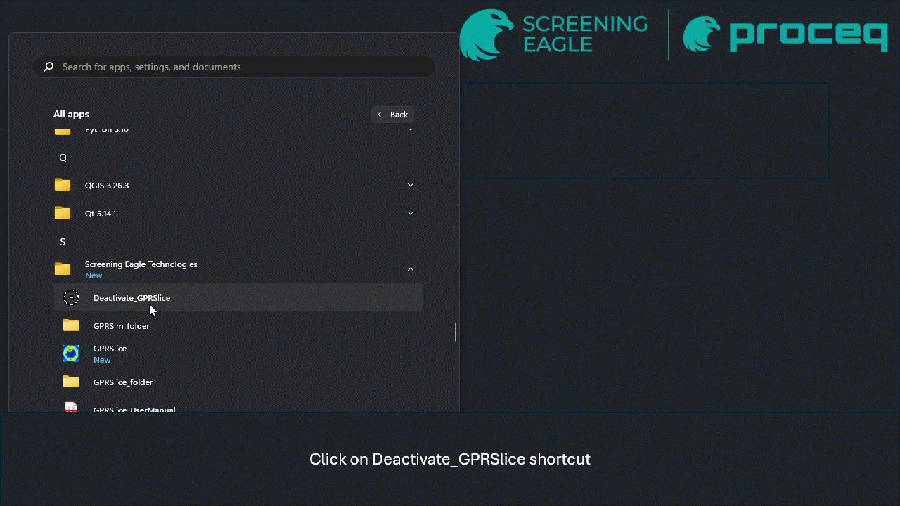
License deactivation tool
The network license can now be deactivated (to move it to different computer) with visual feedback
Legacy downloads:
GPR-SLICE Update (for USB-key licenses) - 10 June 2025 (v7.3.0.81)
GPR-SLICE Library Update - March 11, 2024 - 15:00 CET
GPR-SLICE Setup
GPR-SLICE Manual 2021
Information
For USB version, Microsoft Windows Defender may give a warning about presence of Trojan:Win32/Phonzy.B!ml inside. This is a false positive detection, the file is safe to use.
New Functionalities
(v7.3.0.81) Improved handling of Impulse Radar Raptor Multichannel multiplex and IDS Chaser.
(v7.3.0.79) Added UTSI Electronics Triview format.
(v7.3.0.78) Handling new GPS format for Raptor.
(v7.3.0.75) Option to add vector max compilation on a 4 column survey rather than just vector addition.
(v7.3.0.75) In the GPS track menu an option on Set Vector to interchange coordinates to easily make vector adjustments on surfaces - such as a square column.
(v7.3.0.75) BlueBox operations were not included with MC Proceq equipment.
(v7.3.0.73) Improvement in reading GPS files for Proceq GS9000 device.
(v7.3.0.73) 3D median filter (3x3x3, 5x5x5, 7x7x7 and 9x9x9).
(v7.3.0.73) New multiplex format for Impulse Radar.
(v7.3.0.71) Added median filters (3x3, 5x5, 7x7, 9x9, 11x11) in the Grid menu.
(v7.3.0.69) Support for Total Station positioning for Proceq devices.
(v7.3.0.67) Channel calibration controls expanded from 40 to 100.
(v7.3.0.59) Added a tool to manage network license (deactivate it).
(v7.3.0.53) Topographic corrections to a depth corrected radargrams.
(v7.3.0.53) Option for depth converted radargrams to adjust them to follow horizons with different (2D) velocity models.
(v7.3.0.53) Support for new Raptor GPS files.
(v7.3.0.52) Proceq SEGY - GS9000 and Mala Mira Compact support.
(v7.3.0.49) IDS Stream UP/DP now supports 16 and 32bit data. For users of USB-key-protected version, download of GPR-Slice Library Update is needed too.
(v7.3.0.49) ImpulseRadar importer supports new format of *.iprh files. For users of USB-key-protected version, download of GPR-Slice Library Update is needed too.
(v7.3.0.45) Mala importer can handle GPS log files where latitude is written as negative number instead of "S" letter for southern hemisphere
(v7.3.0.45) Installer now supports command line switches (-v standard, -v multichannel, -v road, -v usb) to allow for selection proper version in silent install mode
(v7.3.0.43, v7.3.0.44) Added GSSI Flex Single / Dual importer
27/07/23 Added option to reimport drawn objects as a separate layer on the OpenGL drawing (using import button)
7/06/23 Added support for large Proceq area scans (SEGY import)
5/22/23 Added support for IDS Stream Up
5/22/23 Added support for multichannel SEGY (exported by Kontur)
3/8/22 Unification of Pundit importers in CreateInfo screen
2/8/22 Transfer utilility browser supports more file filters (for IDS devices)
1/25/22 Added support for Proceq GP8100 measurements
10/13/21 Impulse Radar Raptor new version 1 GPS format added to the Edit Info File menu
10/8/21 Auto removal of scan number <=0 on using the customized XYZ to NAV import button in the Edit Info File menu
9/17/21 Dip angle limit default reset to 35degrees from 55degrees for sharpening migrations in the near field
9/15/21 New button in the Edit Info File menu to convert straight line GPS files to regular XY survey information info-gps-xy.dat
9/4/21 Export to *.rd3 and *.rd7 allowing for downsampling or upsampling from original Mala files added to the Filter menu
9/1/21 Proceq infoxy and infoLF/HF import option adjusted to read mixed units in the *.csv files
8/31/21 FK filtering speed improved to approximately 4 times using new vector graphics displays
8/25/21 Message warning added to Raptor to UTM button when there is no overlapping times between *.time and *.gps files. *.cor file navigation unaffected
8/17/21 Parse GPS files extended to read a single rectangular track recorded file with GPS file notation - but then to convert to an info-ang.dat file with parsed profiles in the \radar\ folder - option auto creates the info-ang with NGPS parsing set to 1 (which is equivalent to 2 GPS listings)
8/16/21 Mala to UTM button adjusted to handle Unix files with just line feeds and no carriage returns
8/9/21 Del Nth button converted to 2 separate buttons called Delete Up/Delete Dn to edit the info file in either direction in the Edit Info File menu
8/8/21 Perpective transformation of Zscans in OpenGL onto a user defined quadrilateral drawn on an imported photograph
8/6/21 Batch operations for krigging will now run the variogram setting for the range and sill in the background for each individual grid - rather than just using the settings for these parameters from just the first grid
8/4/21 XYpoints file and OpenGL Edit Objects file exported with columns of XYT&Z added to the upper menu - and simply uses the single velocity set in the Options menu - full horizon exports is only available through the Static pulldown menu
8/3/21 US Radar GPS file generation programmed to continue with missing log files
7/20/21 US Radar version 5 GPS/TS log file format added
7/15/21 Improvement of GPS filter on endpoints
7/13/21 Scan 0 forced to scan 1 in import of customizable navigation files on the XYZ to NAV button in the Edit Info File menu
7/11/21 Save All and Save From buttons renamed in the Pixel Transform menu to Copy to All and Copy From to avoid confusion in resetting all transforms to the active transform
Bug Fixes
(v7.3.0.80) Fix for menu items not being stored or read when importing external 3D data.
(v7.3.0.79) Improved importing of positioning information for Impulse Radar, when using .gps not .cor files.
(v7.3.0.78) Fixed a problem with OpenGL window not being resized properly if different resolution monitors are used.
(v7.3.0.77) Fixed a crash during radargram editing due to an initial setting of 0 for the velocity. Now, if it is set to 0, it will be automatically increased to 0.1.
(v7.3.0.77) Pixel Map menu was showing incorrect header information for absolute elevation.
(v7.3.0.77) Fixed a crash in Radar Edit, whn the scan mode graphics was not set.
(v7.3.0.76) Fix for the problem with populating SEGY names for Proceq GS9000 measurements in certain cases.
(v7.3.0.74) Fix for swapped axes in Proceq measurements done with total station.
(v7.3.0.65/66) Improved autogain for OpenGPR 32bit data.
(v7.3.0.64) Fixed DC offset calculation for Proceq data.
(v7.3.0.63) H-Calibration gain was not working properly for 32bit data.
(v7.3.0.62) With absolute elevations engaged, the dxf export on isosurfaces was showing relative locations instead of absolute ones.
(v7.3.0.61) Fixed a bug causing the isosurfaces not to be properly exported from graphical to real coordinates.
(v7.3.0.61) Fixed problems with IDS Stream Up and DP importers.
(v7.3.0.60) Fixed a problem with converting data from IDS DP system.
(v7.3.0.60) Missing IDS GetTS button for IDS Stream UP device.
(v7.3.0.60) X, Y, T values were not updated in realtime during 3D movements locked into any realtime or a GPS radargram.
(v7.3.0.60) A button for creating navigation files for Proceq GS9000 measurements was missing.
(v7.3.0.60) Fixed a problem when loading SEGY data from Proceq GS8000 device.
(v7.3.0.59) Fixed a problem with OpenGL xyz-2d operation, where a 2d time slice is flanked by x and y radargrams and as the user clicks anomalies on the zscan, the closest approach radargrams in x and y directions was not updated.
(v7.3.0.58) Small improvements.
(v7.3.0.56) Improvements in autogain function to mitigate the corrupted amplitudes problem.
(v7.3.0.55) Fixes in batch topo correction + tilt operation.
(v7.3.0.55) Fixes in OpenGPR importer for IDS Stream DP.
(v7.3.0.54) Fixed small issues Mala Mira Compact importer.
(v7.3.0.51) Fixed small issues in IDS Stream UP/DP importer.
(v7.3.0.51) Fixed small issues Proceq importer.
(v7.3.0.50) Improved handling of IDS Stream UP for very long profiles.
(v7.3.0.48) Fixed radargram not being scaled correctly when 3D volume was not present in OpenGL window.
(v7.3.0.48) Fixed a broken functionality of "Export w/Elevation" button in the XYpoints menu.
(v7.3.0.46) Fixed minor issues with USB-key handling.
(v7.3.0.41) Fixed a bug in the export of isosurfaces dxf files, where the real georeferenced coordinates were not written correctly.
(v7.3.0.40) Fixed options / configuration files in the installer
(v7.3.0.40) Fix for the bug causing "This version of GPR-SLICE has expired" message
(v7.3.0.38) Fixes in GSSI Flex Single and Flex Dual importers
11/6/23 Fixed the JPG button for batch processing in bridgedeck module
6/3/23 New mechanism to get satellite image from Google Maps. For users not using All-in-one-installer, download and install of Microsoft Visual Studio 2022 redistributable and Microsoft WebView2 is neccessary
6/3/23 Extended the width of element showing project path to accomodate for long paths
14/02/23 Fixed the time column not being updated when GPS time lag correction was applied
10/02/23 Fixed a minor bug for georeferencing an information file
10/02/23 Fixed the import for (drill) core files and showing the proper depth of the cores
16/01/23 A bug in the display wiggle traces for 32bit radargrams functionality
09/01/23 Help and webpage link were not working if no project was opened
23/12/22 Height of rectangles in OpenGL Draw menu not drawn correctly after storing to the object files when using the active "h" or "l" hotkeys to change heights
20/12/22 Fix in saving isosurfaces to txt file
10/10/22 Fix in generation of KMZ files
9/19/22 Fix in the display of slice window information (show only 25 entries)
8/20/22 Fixed an issue with Google Maps displaying For Development Use Only message
8/20/22 Fixed an issue in Compile frequency and maximum amplitude function
8/5/22 Improvements in Radar Tunnel Warp
7/13/22 Removed unused button (Compile time from max amplitude) in the Pixel Maps menu
6/14/22 Improvements in batch Topo+Tilt correction
5/31/22 OpenGL Topo Volume Warp - the real time zt - level plane time slice from a topo warped volume, was not updating the animation list frame start/end
5/31/22 For Z-level displays of the time window and the depth were incorrect
5/2/22 Horizon correction was not working properly
4/8/22 Fix for new format of Mala cor files (longitude written as negative value)
3/22/22 Fix for parsing error when loading ASCII data written in column format
2/21/22 Blank screen when trying to acquire satellite image from Google Maps
7/2/22 Lines parallel to X axis were incorrect (for Proceq GP8100 measurements)
1/24/22 FK plot was upside down
1/12/22 XY points were incorrectly placed after use of custom range length (to split long radargrams)
12/23/21 Raptor to UTM not working properly to identify GPS on every scan during navigation creation
12/2/21 XYZ to NAV button not working when the scan number column is not identified on customized import of GPR/nav files
11/29/21 Scroll bars not appearing on the info file append drop down menu in the Create New Info menu
11/24/21 Exported DXF pipe functions for GPS volumes shown at half the length
11/19/21 AGC in the Spectra+Gain menu not reading the active scroll +/- button to generate an automatic gain curve on the data (400 scans) shown to the screen
11/8/21 Truncate Horizon 1 not working for GPS radargrams where scans exist before or after the first and last GPS tagged scans
9/16/21 Cursor position labeling removed when active pulse window following the mouse movements on multi-radargram displays (labeling preserved at the bottom of the pulsewindow)
9/13/21 64bit volume ascii export not working; fast volume export writing code removed
9/12/21 Migrator scan width limited to a minimum of 3 scans
9/6/21 First installation and directly going to Hyperbola Search menu not showing profile display
9/1/21 Vector volume 2d grid file extraction not preserving the header as depth on display in the Pixel Map menu
8/31/21 64bit volumes converted to topographic volumes not working
8/31/21 FK radargram filtering not working for GPS radargrams
8/29/21 Compilation of frequency at maximum amplitude not working for GPS projects on the first profile
8/25/17 Import of 3D geophysical data not reading in the column multipliers other than set to 1 properly on import
8/10/21 New virtual-3 option not working for volumes with null data
8/7/21 Matrix inversion algorithm incorrect - affecting krigging and spiking deconvolution
8/5/21 Proceq infoxy auto read not recognizing 2 different designations for feet or ft units
7/27/21 Real time depth and time displays following the cursor not working in Horizon menu when the sample end is something other than the native pulse length
7/26/21 Import 3D geodata not recognizing tab delimited data
7/23/21 24 hour bug on Array to Nav for Raptro equipment
7/22/21 *.gec time column for IDS equipment not being written into the *.gps files
7/22/21 Depth radargrams not working on GPS files
7/16/21 Velocity setting gets set to 0 on entering the Horizon menu
7/15/21 Vertical displays of vector volumes not properly showing the depth labeling on the Zscan